
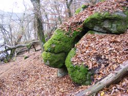
Podzim na řece. / Autumn on the river.
Včera v neděli 15.11. 2020, jsem uskutečnil výlet s přáteli do Bukovanské zátoky a na naše letní skautské tábořiště, na Vystrkově.
Na jedné fotce jsou zachyceni i dvě osobní auta. Rodinky dojeli přes zákaz až na pláž. Lidé se prostě k přírodě chovají neuctivě.
Yesterday on Sunday 15.11. In 2020, I made a trip with friends to Bukovanská Bay and our summer scout camp, Vystrkov.
Two cars are also captured in one photo. The families reached the beach despite the ban. People simply treat nature disrespectfully.
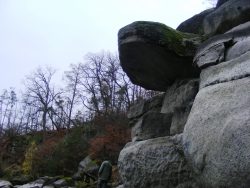


Lokalita bývalého lomu kousek nad obcí Těchnice. Spodní část zatopena hladinou Orlického jezera, nad hladinu vystupují dvě vysoké svislé stěny. Na pravé stěně je nakreslen hrubý vodočet, vyznačující aktuální nadmořskou výšku hladiny.
Ze žuly zdejšího lomu je například postaven Negrelliho viadukt, který v Praze spojuje Masarykovo nádraží přes ostrov Štvanici s Bubny.
Strmé stěny končí na plošině v hloubce asi osmi metrů. Zde je množství velkých žulových kvádrů se stopami po těžbě, bývá zde mnoho ryb. Pod stěnou s nakresleným vodočtem leží vrak starého Olcita. Leží strmě pod stěnou v hloubce přibližně deseti metrů. Dlouho bylo potápěčům záhadou, jak se sem vrak auta dostal, když nad lomem není žádná cesta. Auto dojelo na místo po vlastní ose – po zamrzlé hladině. Led pod ním ovšem povolil a tak máme vrak. Dnes (jaro 2007) je už trochu pošramocený, zmáčknul ho led při upouštění hladiny v zimě.
Z plošiny směrem do hlavního toku pokračuje prudký svah. Dají se zde najít zbytky přístupových cest, dobře znatelná podezdívka, zídky a v hloubce okolo deseti metrů i několik pražců od kolejí pro těžební vozíky. Nejzajímavější potápění je mezi hladinou a dvaceti pěti metry. Ve velké hloubce nalezl David Vondrášek dva důlní vozíky, ale najít je znovu asi nebude jednoduché.
Location of the former quarry just above the village Těchnice. The lower part is flooded by the surface of Orlické Lake, two high vertical walls rise above the surface. A rough water meter is drawn on the right wall, indicating the current altitude.
For example, the Negrelli viaduct is built from the granite of the local quarry, which in Prague connects Masaryk railway station via the island of Štvanice with Bubny.
The steep walls end on a plateau at a depth of about eight meters. There are many large granite blocks with traces of mining, there are many fish. Under the wall with a drawn watermark lies the wreck of old Olcit. It lies steeply under the wall at a depth of about ten meters. For a long time, it was a mystery to divers how the car wreck got here, when there is no road above the quarry. The car reached its place on its own axis – on a frozen surface. However, the ice beneath him let go and so we have a wreck. Today (spring 2007) he is already a little battered, he was squeezed by the ice when the water level dropped in winter.
A steep slope continues from the platform towards the main stream. Here you can find the remains of access roads, a well-visible baseboard, walls and at a depth of about ten meters, a few sleepers from the tracks for mining trucks. The most interesting diving is between the surface and twenty-five meters. At great depths, David Vondrášek found two mining trucks, but finding them again will probably not be easy.
http://www.stranypotapecske.cz/lokality/lokaldet.asp?lok=470
